

Meet Victor Coll, a seasoned expert in the art of in-bound content marketing. With a proven track record in crafting winning content strategies, Victor excels in attracting and engaging audiences organically. His proficiency extends to optimizing content for maximum impact, resulting in increased brand visibility and audience retention. Victor's dedication to the art of in-bound content marketing has helped businesses achieve remarkable growth. Join him as he shares invaluable insights and strategies to empower your content marketing efforts and drive meaningful connections with your target audience.
Get in touch
555-555-5555
mymail@mailservice.com
What Is Drone Mapping?
WHY PAY MORE?
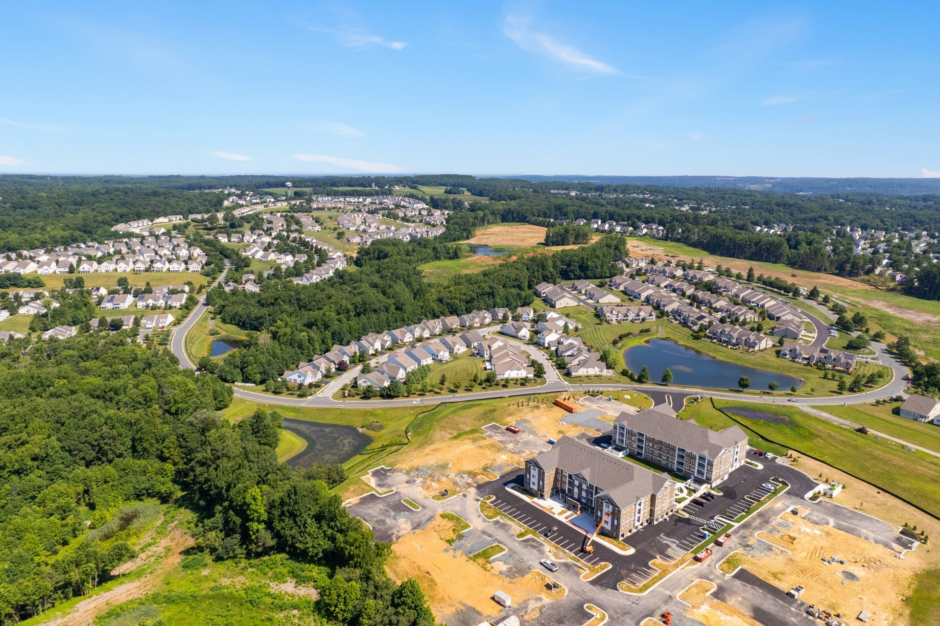
Photogrammetry . Now there’s a word you don’t hear every day, nor is it likely to be tossed around in casual conversation. Doubtful it was a word that Mr. Rogers had you pronounce as a child. Same goes for the word orthomosaic . It, too, is not likely to be on your list of oft-uttered words. But the truth is, the real estate industry has been affected by both for years. Today, drone photography is taking the world of photogrammetry to the next level with drone mapping , making possible state-of-the-art orthomosaics that are used in real estate marketing and a host of other industries.
Actually, the science of making measurements from photographs, also known as photogrammetry, has been around for more than a hundred and fifty years. It has been used to derive accurate measurements from drawings, 3D models, and aerial maps. In fact, many of the maps in use today have been created with photogrammetry and the pictures taken from a helicopter or airplane.
Closely related is the concept of creating a detailed image, an accurate photo representation of an area, out of many photographs that have been stitched together and geometrically corrected (orthorectified) so that it is accurate as a map, an orthomosaic.
For many years, aerial photogrammetry was performed with a camera mounted in an aircraft, an operation that is fast becoming an errand of drones that are capable of capturing thousands of images that can be assembled into a highly-detailed map with the accuracy of a land survey. Drone mapping is a powerful tool to create 2D maps and 3D models that deliver value across many industries, including engineering, construction, general contracting, surveying, and real estate.
As an agent, you are already familiar with photogrammetry in another arena: 3D virtual tours , where a 3D camera captures hundreds of images that are stitched together to create a digital twin of a house, apartment, business , or any other physical space. Just as the immersive experience of a virtual tour goes beyond what 2D images can produce, the capabilities of drone mapping extend beyond traditional methods for capturing aerial images.
For example, fixed-wing aircraft fly thousands of feet above their targets. A drone , on the other hand, flies just hundreds of feet above ground when capturing data for mapping. Airplanes must contend with things like low clouds, which can delay a photo shoot , whereas drones can fly almost anytime regardless of cloud cover.
The amount of time required for drone mapping is less than that of traditional aerial mapping services. It can take weeks of planning to schedule a flight, followed by weeks to complete the mapping process. Many drones can lift off the same day, and the results of their fly-overs can be processed (in many cases) overnight.
Cost is certainly a factor between fixed-wing aircraft and drones . The camera technology used in a drone is usually far less expensive than that used in an airplane. And the results? Better resolution because of the low-altitude proximity to its target. What’s more, a drone certainly does not cost nearly what an airplane or helicopter might.
And drone operation does not require a pilot’s license. It might be handy and even recommended, but it is not required. A remote pilot certificate, good for two years, is needed, but that is not the same as an FAA license.
There are some downsides to drones. They are small and lightweight. That means they cannot fly well in the wind. Their battery life is (for now) limited, with average flight times ranging from fifteen minutes to an hour, allowing them to cover a limited area, about fifty to a hundred and fifty acres per flight. An airplane can cover thousands.
Still, drone mapping services are easily accessible, accurate, and affordable.
What does all of that mean for real estate?
Aerial maps have long been useful aids in the sale of land. Because of the accessibility of drone mapping, that usefulness has expanded to include more than large areas of real estate. An up-to-date map can be a valuable tool to determine whether a property is a good fit for a buyer. With the accuracy of a survey, drone maps afford a view with far more detail than those taken from aircraft or satellite. Those details can serve when a buyer cannot visit a property in person. And with the help of a licensed land surveyor, accurate borders can be overlaid onto the images provided by drone mapping.
Of course, drone photography goes beyond mapping. Just as a virtual tour can serve as an online open house for a property, a neighborhood showcase, or even a highlight of your business on Google Street View , a drone can serve multiple purposes. Drone photography can provide a budget-friendly solution for aerial photography, superior views of your premium properties that are hard to photograph from the ground, expanded overlooks of the land, and tours of the town.
It is no secret that home buyers rely on online listings to locate prospective new homes, especially in the age of social distancing and concerns over the coronavirus . Therefore, real estate agents are constantly tasked with providing creative marketing tools to represent properties for their sellers and to their buyers. Modern drone mapping techniques make it easy to create clear and accurate aerial images of homes without spending ridiculous amounts of time or money to impress your clients. And with words like photogrammetry and orthomosaic , you might have even impressed Mr. Rogers.


Real Estate Photography Blog Categories
Get an aerial view of your property with drone photography. Highlight features, attract buyers, and make your real estate listing stand out from the rest. Book Your Drone Shoot Today!

Top 10 Services Offered by Real Estate Agents

Discover the TOP REAL ESTATE COMPANIES for 2025, from luxury LEADERS to tech disruptors. Find the best brokerage for buying, selling, or investing today!
Get more clicks, attract serious buyers, and sell homes faster! Discover 10 powerful reasons why professional real estate photography leads to higher sales and quicker closings.
CONTACT US
Brought to you by
1 Texas Station Court
Suite 130
Timonium, MD 21093
FOLLOW US
