

Meet Victor Coll, a seasoned expert in the art of in-bound content marketing. With a proven track record in crafting winning content strategies, Victor excels in attracting and engaging audiences organically. His proficiency extends to optimizing content for maximum impact, resulting in increased brand visibility and audience retention. Victor's dedication to the art of in-bound content marketing has helped businesses achieve remarkable growth. Join him as he shares invaluable insights and strategies to empower your content marketing efforts and drive meaningful connections with your target audience.
How to Get an Aerial Shot of Your Property
WHY PAY MORE?
How to Get an Aerial Shot
of your property
See Your Property Like Never Before—From the Sky!
By [Victor Coll] | Last Updated March 20th, 2025 | 3 min read
Buying or selling a home is one of the biggest financial decisions a person can make. And while the process might seem straightforward at first—list a home, find a buyer, sign the papers—there’s a lot more that happens behind the scenes. That’s where a professional real estate agent comes in. A top-tier agent doesn’t just help clients buy or sell a property; they offer a full suite of services designed to streamline the process, maximize value, and reduce stress.
If you’re in the market for a home or looking to sell, understanding the services real estate agents provide can help you make an informed decision when choosing the right agent for your needs. Below, we’ll explore the top 10 services offered by real estate agents that make the home buying and selling journey smoother and more profitable.

See Your Property Like Never Before—From the Sky!
Ever wondered what your property looks like from above? Whether you're a homeowner, a seller, or a real estate pro, an aerial view gives you a whole new perspective—literally. From showcasing property layout to highlighting outdoor features, aerial shots help potential buyers visualize a space in ways that regular real estate photos just can’t.
In today’s fast-moving market, standing out is everything. Aerial imagery makes your listing pop, grabbing more views and engagement. Whether you're trying to define property lines, show off a backyard oasis, or create stunning marketing materials, having an aerial view of your property is a total game-changer.
So, how do you get one? Easy! Many professional real estate photography companies offer drone photography and aerial video services that capture stunning shots of your home. If you’re just looking for a simple overhead view, free online tools and satellite services can also do the trick. In this guide, we’ll cover the best ways to get those breathtaking aerial shots and make sure your property gets the attention it deserves.
Benefits of Including Drone Photography
of a House
A real estate listing with an aerial view isn’t just a nice visual bonus—it’s a powerful selling tool. Drone photography helps homebuyers see the full property layout, lot size, landscaping, and surrounding area—all in one frame. And with 96% of buyers starting their home search online, high-quality real estate photos with aerial perspectives can instantly make your listing more clickable and more memorable.
Stand Out from the Competition
Let’s be honest—most listings start to blur together after a while. While traditional real estate photos focus on interiors and curb appeal, drone imagery captures the bigger picture: the full surroundings, property lines, nearby amenities, and context within the neighborhood. This not only helps buyers visualize the space more clearly—it positions your property ahead of competing listings.
Showcase Unique Property Features
Have a sprawling backyard? A scenic view? Maybe a pool, rooftop deck, or prime location near a park or golf course?
Aerial shots
highlight these
outdoor features
in ways ground-level photos simply can’t. Whether it’s a cozy starter home or a luxury estate, drone photography adds instant impact, making your listing more engaging and helping attract serious, ready-to-act buyers.
Ways to Get an Aerial View of Your Property
If you’re wondering how to get an aerial view of your property, you’ve got options. Whether you need high-resolution images for a real estate listing or just want to get a bird’s-eye view of your land, here’s how to make it happen.
Option 1: Professional Real Estate Photography and Drone Services
Want crisp, high-quality aerial images? Hiring a professional real estate photography company is the way to go. These experts use licensed drone operators to capture aerial video and drone photography from all the right angles. The result? Crystal-clear shots that highlight your property’s layout and outdoor features beautifully.
With professional real estate photography, you also get control over photography framing—making sure your property lines and surroundings look just right. If you’re selling a home, this is hands-down the best way to make your listing stand out.
Option 2: Satellite Services and Free Online Tools
If you just need a quick aerial view of your property, satellite services can work too. Tools like Google Earth let you check out satellite images of your land for free. But be warned—these images are often low-resolution and don’t always show property lines or smaller property features clearly.
For more advanced aerial views, organizations like the Geostationary Operational Environmental Satellites (GOES) provide global imagery. But keep in mind, these are meant for weather tracking—not for real estate marketing.

Drone Photography vs. Satellite Images—What’s Right for You?
So, which method is best? It depends on what you need. If you're just curious about your land size or general property boundaries, satellite images might be enough. But if you’re selling a home or want professional-level marketing materials, aerial photography from a real estate photography company is the clear winner.
Aerial Photography for Real Estate Listings
If you’re in real estate, high-resolution images aren’t optional—they’re a must. Aerial photography gives buyers a full view of the property layout, making your listing more appealing and helping homes sell faster. Plus, sharp aerial images help you stand out in a competitive market.
When Satellite Images Are Useful
If all you need is a basic look at your property, satellite images from tools like Google Earth can get the job done. They’re great for general layout views but don’t offer the high-resolution images needed for real estate marketing.
If you want to wow buyers, aerial photography is the way to go. If you just need a simple top-down view, satellite imagery can help—but it won’t give you an edge over the competition.
Sell the Full Story with Aerial Drone Photography
A drone-captured aerial view of your property gives buyers the complete picture—from layout and land size to outdoor features and neighborhood context. Whether you're a homeowner showcasing your land or a real estate professional looking to drive engagement, aerial real estate photos are a powerful way to elevate your marketing.
While tools like satellite images provide a basic overview, they lack the quality and detail needed to influence purchasing decisions. For high-resolution, marketable visuals, drone imagery and professional real estate photography remain the gold standard.
These sharp, strategic images do more than beautify—they increase clicks, highlight key features, and help buyers make faster, more confident decisions.
Ready to give your listing a competitive edge?
Book an aerial shoot today
and let your property stand out—online and on the market.


Real Estate Photography Blog Categories
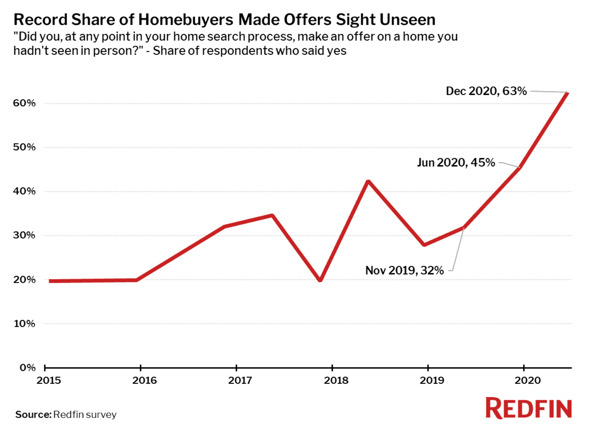
Buying a Home You've Never Actually Walked Through — Welcome to the New Normal

Balanced Lighting: The Trust Signal Buyers Rely On
Clean Vertical Lines and Buyer Confidence

How Color Accuracy Shapes Buyer Perception